Overview
Discover Ecuador’s ethnic and ecological diversity with CEDEI this semester!
CEDEI’S Spring Semester in the Andes combines quality academic content with an extended intercultural and language experience. Live and study in Cuenca, Ecuador, while also traveling to some of South America’s must-see sites: the Galapagos Islands!
Our semester is open to students from a wide range of majors with or without previous Spanish knowledge.
Participate actively with locals and get a unique cultural experience by living with a host family! Visit local sites of interest such as and museums, national parks and Incan ruins! Gain skills in Latin rhythms with our dance classes, learn how to prepare traditional food with our cooking classes and explore your creative side in our pottery workshops.
Students interested in CEDEI's Spring Semester in the Andes can contact us at oip@cedei.org.
Program Calendar
Our program is designed to offer you the most enriching experience abroad. Our team works hard to ensure you receive superior quality education while becoming culturally competent in Latin America. Learn about the customs of Ecuador’s diverse ethnic groups and participate actively in everyday life with locals!
Our program set-up also offers you the opportunity to enjoy Ecuador’s 4 regions: Coast, Highlands, Amazon and Insular Region (Galapagos Islands) during our various cultural excursions.
The Spring Semester is divided in two quarters and students can enroll in up to 3 courses each quarter (18 academic credits in total).
We are currently working on the Program Calendar and will launch soon!
*This page contains PDF documents. To open, a PDF reader is required. To download a free reader, follow the link: Adobe Acrobat Reader.
Course Catalog
Please review our course catalog
Understanding course descriptions: The first line of each description includes the course number and title; credits are indicated in parentheses.
At the end of each description is a link to the course syllabus, if available. Not all courses are taught every semester. The syllabi are to be used as a general guide.
Please, contact us if you have specific questions, concerns, need to verify that a syllabus is up-to-date, or would like to explore other course options.

Included Travel
Quito
Quito, formally San Francisco de Quito, is the capital city of Ecuador, and at an elevation of 2,830 meters (9,350 feet) above sea level, it is the highest capital city in the world housing the country’s administrative, legislative and judicial functions. The students will visit the Capilla del Hombre, the famous museum containing many works by Ecuadorian artist Oswaldo Guayasamín, and they will also participate in a City Tour, visiting the historic center, La Catedral, La Compañía de Jesus, buildings of political importance, and many other culturally relevant sites located throughout the city.
- Altitude: 2,830 m (9,350 ft)
- Normal Temperatures: 10° - 27° C (50° - 80° F)
- Climate: Subtropical Highland
- Number and difficulty of hikes: 1 city tour, 2/10 difficulty.
Otavalo
Our students visit Otavalo, located north of the Equator and about 100 kilometers north of Quito, the capital. Here, the tranquil streets and sprawling markets will provide an interesting contrast to the modern city of Quito. In recent times, the market has begun to focus strongly on the tourist trade, although thousands of indigenous from the surrounding communities still descend on market day to buy and sell. They are considered to be one of the most successful indigenous groups in Latin America, and can be found selling their wares in almost every Ecuadorian city, as well as in Europe and the United States. While in Otavalo students will visit Taller Mindada, a cultural site specializing in the local history and development of various textiles, as well as a musical workshop where students will be able to see the creation of a simple Andean instrument and try playing others.
- Altitude: 2,550 m (8,415 ft)
- Normal Temperatures: 10° - 27° C (50° - 80° F)
- Climate: Dry, Mediterrean-Temperate, Sub-Andean Valley
Mitad del Mundo
The Mitad del Mundo (Middle of the World) monument in the town of Cayambe, between Quito and Otavalo, marks the place where, in 1736, Charles-Marie de La Condamine’s expedition made the measurements that located the Equator. Despite this accomplishment the French team of scientists was off by 300 meters, an error which was discovered upon the invention of the global positioning system GPS. Nevertheless, it is a great place to get a photo with one foot in either hemisphere. A pre-Columbian monument from one of Ecuador’s pre-historic cultures was discovered on the hill in front of the monument, on the exact line of the Equator. There is also a museum that contains a model of Quito, a planetarium, various exhibits, several restaurants, an open arena that is occasionally used for folkloric-dance performances, and a small chapel where couples can marry with one spouse standing in the northern hemisphere and the other in the southern.
Amazon Rainforest
Our students travel to the Oriente; moving from the high altitude of the Andes, to the lush rainforests on the eastern side of Ecuador. This trip highlights the diversity that Ecuador has to offer, and is an important part of the semester. We visit Misahualli, which is the river port of the Ecuadorian Amazon. It is a natural resort with white sand rivers, decorated with dozens of trees that are home to capuchin monkeys. The port is located at an altitude of 517 meters (1,700 ft) above sea level, with an average temperature of 25° C, and is part of the high forest. Its main characteristic is the abundant biodiversity per square meter, one of the largest in the world in number of endemic species of flora and fauna. The most important natural attraction is its sandy beach about 700 m. long, which is the point of entry for jungle excursions.
- Altitude: 517 m (1,700 ft)
- Normal Temperatures: 23° - 30° C (73° - 86° F)
- Climate: Humid Tropical Rainforest
- Number and difficulty of hikes: 1 hike, 5/10 difficulty.
Salasaca & Patate
Salasaca is a village inhabited by some 12,000 Salasaca Indians famous for their exquisite tapestries, history, and for being one of the most vibrant indigenous cultures of Ecuador. This group which was once located in Bolivia, but was conquered by the Incas and forced to move, thereby being less of a threat to the Incan empire. This tribe is considered one of the most interesting ethnic groups because of their surly and rebellious social behavior, strong traditions and customs their reluctance to mix with whites, and because they still live in relative isolation. As you head southeast from Salasaca towards río Patate, nestled precariously in a steep valley you will begin to catch smoky glimpses of the famous Volcán Tungurahua, the 5,016m peak which is always threatening imminent eruption. From the town of Patate, where you will be staying in the Hacienda Leito, you might get the chance to hear, feel, and see Tungurahua giving a spectacular show of bursting lava cascading down its sides. Not to worry, although the hacienda in Patate sometimes will receive a light dusting of ash, there is nothing to be concerned about for it is at a safe distance from the thundering giant.
- Altitude: 2,200 m (7,260 ft)
- Normal Temperatures: 7° - 18° C (45° - 64° F)
- Climate: Subtropical Highland/High Montane Forest
- Number and difficulty of hikes: None
Ingapirca Archaeological Site
The ruins of Ingapirca, located approximately two and a half-hours from Cuenca, are the most important Incan ruins in Ecuador. Ingapirca is set on a picturesque hillside and overlooks a small village of the same name. The area surrounding the ruins is used primarily for agriculture and raising cattle, with traditional methods (hand and animal power) still used by the majority of farmers.
The main structure, the so-called Temple of the Sun, demonstrates some of the Incas’ finest mortar-less stonework, and is surrounded by seemingly less important ruins thought to be residences and storehouses. There is still debate over the use of the ruins, and archaeologists have at times referred to the ruins as a temple, fortress or as a royal stopover for imperial runners between Quito and Tomebamba (Cuenca).
- Altitude: 3,210 m (10,300 ft)
- Normal Temperatures: 10° - 27° C (50° - 80° F)
- Climate: Subtropical Highland/Valley
- Number and difficulty of hikes: 1 hike/walk, 3/10 difficulty.
El Cajas National Park
Declared a national recreation area in 1977 and a national park in 1996, "El Cajas" ("boxes") covers an area of 29,000 hectares (72,000 acres) of mountainous terrain between 9,700-13,500 feet. The park is situated on the western cordillera at the continental divide, about 30 km west of Cuenca. A once-glaciated region (note the "U"-shaped valleys and craggy peaks) over 400 lakes and lagoons formed after the last ice age, around 12,000 years ago. Today, the park is littered with these paternoster lakes, all interconnected by visible and subterranean rivers and waterfalls. High altitude and moisture are the dominant climactic variables in El Cajas, forming two interesting ecosystems: Montaine cloud forest and Andean páramo, or shrubby high altitude grassland.
- Altitude: 2,940 - 4100 m (9,700 – 13,500 ft)
- Normal Temperatures: 0° - 25° C (32° - 77° F)
- Climate: High Montaine Forest/Andean Páramo
- Number and difficulty of hikes: 1 hike, 7/10 difficulty.
Saraguro
Like the people of Salasaca, the Saraguros were originally sent to their current location an hour north of the city of Loja – it is thought from Bolivia – by the Incas under their system called "Mitimae," a way of controlling "troublesome" groups. Perhaps for this reason the culture of the Saraguros has remained defiantly strong. Some say that their distinctive black clothing is due to them remaining in mourning for their old home, but the explanation of Saraguro historians is that their dress code comes from their Incan heritage and represents their nobility. In the traditional Saraguro custom the men sport ponytails, hats, black ponchos and knee-length black trousers; the women wear pleated black skirts, shawls fixed with a pin, and the famous wide-brimmed white hats decorated with black spots under the brim.
The area itself is also fascinating. The town center is of the colonial era, with many old mud buildings in the main plaza and streets around it. On Sundays people come from all over the country to buy and sell produce at the Saraguro market, creating a buzz in the normally sleepy town. In the villages that surround Saraguro – such as Gera, Oñakapak and Lagunas – there are great opportunities for hiking and camping.
- Altitude: 2,600 m (8,580 ft)
- Normal Temperatures: 5° - 25° C (40° - 77° F). Very cold at night!
- Climate: Subtropical Highland/Valley
- Number and difficulty of hikes: 1 hike, 7/10 difficulty
Gualaceo & Chordeleg
The small town of Gualaceo hosts the largest indigenous market in the area, where one can purchase fruits, vegetables, meat, spices, etc. There is both an indoor and an outdoor market. You can see indigenous vendors dressed in their colorful traditional clothing. Every Sunday campesinos and tourists come to buy goods. You can find fine woven and embroidered goods and if you get there early enough a very large selection of wool sweaters. In addition, a trip to the animal market could be an unforgettable experience. You may also want to take a walk along the river and visit the town church and plaza. Up the hill is the town of Chordeleg, which is famous for its jewelry and handicrafts museum. Students will also visit a local workshop which specializes in filigree, or fine silver jewelry.
- Altitude: 2,370 m (7,820 ft)
- Normal Temperatures: 15° - 25° C (59° - 77° F)
- Climate: Subtropical Highland/Valley
Girón & Tarqui
Girón is located about 44km southwest of Cuenca and is part of a particular region with great importance to the history of Ecuador. It is in this region where the Battle of Tarquí was fought in 1829 and was a key victory leading to the independence of Ecuador (then called Gran Colombia). Girón is located in the Yunguilla Valley which, with its warm weather, is a favorite weekend haunt of Cuencanos. During the drive you can experience the beauty of this part of Ecuador. There you will be able to hike to three incredible waterfalls, called chorreras, and pass rivers teeming with trout. From the waterfalls you can see the town of Girón in the valley below on a clear day.
Tarqui is located to the south of Cuenca, towards the Yunguilla Valley. Tarqui is the site of a major battle fought between Ecuadorian (Gran Colombian) and Peruvian troops soon after Ecuador’s independence. Despite being outnumbered, Ecuadorian troops won a decisive victory and secured their independent (or Gran Colombian affiliated) status. Today, the area is primarily a dairy-producing region, providing much of Cuenca’s milk.
- Altitude: 2,100 m (6,930 ft)
- Normal Temperatures: 8° - 21° C (47° - 70° F)
- Climate: Subtropical Highland/Valley
Guayaquil
The capital city of the province of Guayas, Guayaquil, is not only the largest city in Ecuador, but also the nation’s main port and the center of Ecuador’s manufacturing and fishing industry. With a current population of approximately 2 million inhabitants, the generally hot and humid climate has transformed in recent years from a seemingly disorganized city to an international destination and the focal point for export of common products such as banana, cacao, coffee, minerals, flowers and textiles. This large natural port on the Pacific coast contains a rich mix of biodiversity as a result of the convergence of the salty Pacific waters and the fresh water from the Guayas river allowing locals to make a living through fishing and collecting a variety of shellfish.
Galápagos Islands
The Galápagos Islands are the non-continental territory of Ecuador. It is a UNESCO World Heritage Site made up of around 19 islands, 16 of which are volcanic. The major islands are Fernandina, Isabella, San Cristobal, Floriana, San Bartolomé, Floriana, Baltra (where the airport is located) and Santa Cruz, where the capital Puerto Ayora is situated. You may get there a two-hour plane ride from Quito or Guayaquil. It is on these islands where you can find the famous Galapagos Turtles, as well as land and marine iguanas, reef sharks, penguins and the playful sea lions. It is known as the best spot for diving in Ecuador. Galápagos, with its extensive variety of species, inspired some of the earliest notions of evolution from the famous naturalist and explorer Charles Darwin. One of the main activities in Puerto Ayora is a visit to the Charles Darwin Station, where you can see and get an explanation of the flora and fauna of the Islands.
- Altitude: 0 - 600 m (0 – 2,000 ft)
- Normal Temperatures: 20° - 30° C (68° - 86° F)
- Climate: Humid Tropical Rainforest/Scrubland
- Number and difficulty of hikes: 3 hikes/walks, 3/10 difficulty.
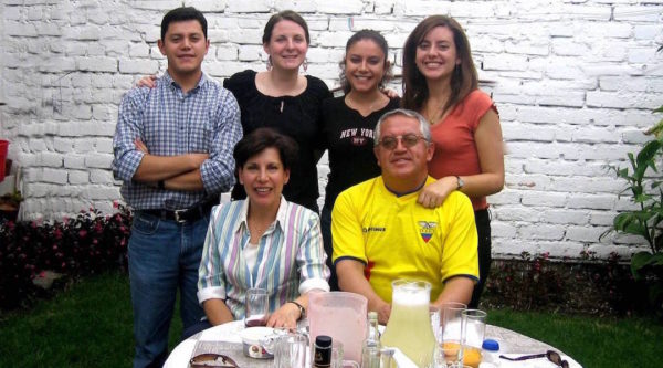
Homestay
As an integral part of our programs, our department offers our students the opportunity to stay with a host family in order to provide them with an invaluable experience. Beyond their normal schedules, the students have the opportunity to be immersed in the culture, customs, and the daily life of Cuenca; an enriching experience for both the students and for the families who host them, resulting in a true cultural exchange.
Taking into consideration that the experience of living with a host family in another country is a very important part of the international studies program, the Department of International Programs has a host family coordinator who is responsible for the careful selection of the families best suited to receive our students in their homes. The evaluation of potential host families will be based on the distance from their house to CEDEI, their motivation(s) for receiving a student, and the willingness and desire of the family to accommodate an international student while sharing their home and personal lives with them.
It is very important that the student fills out the ‘Homestay Questionnaire’ as honestly as possible. Once the homestay questionnaires have been received from our students, the coordinator will then discuss in detail the student preferences, personalities, and interests with their future Ecuadorian family. Our careful process is to assure a pleasant stay with the hopes of an unforgettable and rewarding experience through which our students will create bonds and close friendships with their host families.
Program Cost
| Detail | Cost |
|---|---|
| Tuition | $6,595.00 |
| Room & board (Living with local host families) | $3,000.00 |
| Cultural Trips and Excursions (including orientation trip,Galapagos) and Administrative Fees* | $3,730.00 |
| TOTAL | $13,325.00 |
NOTES: *Program does not include international airfare. No visa application is required, most foreign students can enter Ecuador as tourists for up to 90-days.
IF YOU ARE A STUDENT FROM IOWA STATE UNIVERSITY, SIENA COLLEGE, SYRACUSE UNIVERSITY, TOWSON UNIVERSITY, OR THE U. OF WISCONSIN-WHITEWATER, PLEASE CONTACT THE STUDY ABROAD OFFICE AT YOUR SCHOOL. WE HAVE DIRECT AGREEMENTS WITH THESE INSTITUTIONS
If your school is member of ISEP, please check their website to apply at a discounted cost.

Love and energy"


